On February 26, 2023, Israel and the Palestinians arrived at a number of understandings in the framework of a newly-forged quintet summit in Aqaba, Jordan, in which the United States, Jordan and Egypt participated. This was followed by a summit in Sharm el-Sheikh on March 19, 2023, that sought to solidify and reaffirm the agreed-upon terms, geared primarily towards de-escalation ahead of the overlapping Ramadan/Passover/Easter holiday period.
The understandings, as per the communiques released (here and here), included “an Israeli commitment to stop discussion of any new settlement units for 4 months.”
Since the release of the Aqaba Communique, Israel has significantly expedited construction, with the announcement of 4,089 new residential units in East Jerusalem promoted in its statutory planning committees. Of the units advanced, 2,552 are located within existing settlement neighborhood that extend beyond their current geographical footprint. The remaining units are located in two entirely new settlement neighborhoods. In addition, plans have been advanced for the construction of 500 new hotel rooms.
For the sake of context: in the two months following the Aqaba summit, Israel has catalyzed the construction of a number of units, which constitutes a 6.8% increase in the total number of all the settlement units built by Israel in East Jerusalem since 1967. That figure is also 6.8 times larger than all the residential units built for Palestinians with any kind of Israeli government support since 1967.
In recent days, Israel has taken on-the-ground steps and budgetary allocations to allow for the completion of the Sovereignty/Fabric of Life/Apartheid Road in the area of E-1. The completion of this road will be a major, if not decisive factor, in the de facto annexation of Area C in the Ma’aleh Adumim salient.
New Israeli Settlements/Unilateral Actions: Jerusalem and its Environs Since Aqaba
Hereunder is the relevant text extracted from the communique.
“The Government of Israel and the Palestinian National Authority confirmed their joint readiness and commitment to immediately work to end unilateral measures for a period of 3-6 months. This includes an Israeli commitment to stop discussion of any settlement units for 4 months and to stop any authorization of outposts for 6 months.”
– February 26, 2023
In this context, this update covers the following plans:
- Golden Nof Tziyon
- The Approaches of Gili Project
- Wadi Joz Employment District
- The Ramot Expansion
- The Lower Aqueduct
- The Sovereignty/Quality of Life/Apartheid Road
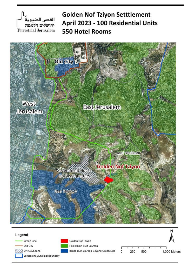
Golden Nof Tziyon
Located in the Jabal Mukkaber/Ridge of the Hill of Evil Counsel (Plan 101-0976597) is a new settlement that consists of 550 Hotel Units and 100 residential units. It was first announced on February 28, 2023 (just two days after the release of Aqaba communique), was approved by the Jerusalem Municipal Committee on March 6, and is to be brought before the District Committee on May 8. The plan was initiated by the Government of Israel, which owns the land. The site is located on one of the most sensitive sites in Jerusalem, the Ridge of the Hill of Evil Counsel, located immediately to the west of the UN Headquarters.
The settlement was the center of past controversy. Initially, the Government of Israel had intended to build the new settlement neighborhood of East Talpiot on the site, so that the new neighborhood would be facing the Old City and the Temple Mount/Haram al-Sharif. Protests erupted against the construction driven by the claim that such construction would destroy the Jerusalem skyline. The protestors succeeded, and the settlement neighborhood was relocated to the southern slopes of the ridge. This new project will reverse the decision from 1970 and establish a settlement impacting Jerusalem’s skyline.
In recent months, we have presented evidence of the Israeli Governments plan to encircle the Old City with settlements and settlement-related activities. Until now, our area of concern were the developments extending from Sheikh Jarrah in the north, to Mount of Olives in the East and Silwan in the south, forming a crescent shape. However, more recently, we have been noting accelerated settlement activity south of Silwan and obtained a map from the Elad Settler organization that discloses their intentions (see above). The new neighborhood dovetails seamlessly with their aspirations.
The Approaches of Gilo Project
This plan (101-1164433) aims to construct 691 residential units in Gilo, beyond the existing footprint of Gilo itself, in the direction of Bethlehem and the Tunnel Road. Despite the fact that Israel makes no claims regarding ownership to the land, and the land is privately-owned by Israeli developers, the Government of Israel filed for the project the on April 17, 2023 by means of the Israel Land Authority. This is yet further proof of the acceleration of settlement activity in East Jerusalem with the strategic objective of creating a buffer between Jerusalem and Bethlehem. It constitutes yet another link in the chain connecting a number of settlement schemes being expedited by Israeli authorities on the southern flank of East Jerusalem nearby including Har Homa C, Har Homa West, Ahuzat Nof Gilo and Har Gilo West.

Wadi Joz Employment District
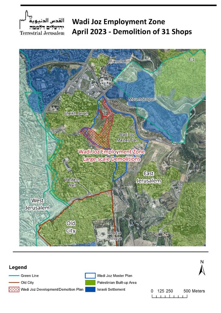
This plan (101-09077694), is also known as the “Silicon Wadi/Valley” Project. For years, the Silicon Wadi Plan has been the flagship of the Jerusalem Municipality’s plans for the development of Palestinian East Jerusalem. Promoted and highly touted by Jerusalem Mayor Moshe Lion, the plan intends to raze the large commercial/auto shop area of Wadi Joz and its 200 businesses. These are located immediately to the east of the areas in Sheikh Jarrah, which have been targeted for evictions, demolitions, and new settlement. Plan 101-097694 is a specific plan that purportedly provides for the construction of high-rise, high-tech buildings, which would entail the demolition of shops on the entire western side of the major artery in Wadi Joz. The District Planning Committee is scheduled to review and consider the plan on May 2.

The Palestinians of Wadi Joz and East Jerusalem believe, and with good reason, that the Wadi Joz Plan will bring few benefits for them. They are skeptical that the promised construction for Palestinian will ever materialize, and fear that the only component of the Plan to be undertaken is the large-scale demolition of 200 Palestinian-owned businesses in Wadi Joz and the razing of the Wadi Joz commercial area. Plan 101-0977694, specifically permits the demolition of the first 31 shops on the main road, designated by yellow frames in the statutory document.
These concerns are substantiated by the actions of the Israeli Government, which is currently advancing two major national projects worth billions of shekels. The first, Plan 3097, is a five-year plan aimed at narrowing the infrastructure and socioeconomic gaps between Israeli and Palestinian Jerusalem. The second plan, run by the Jerusalem Development Authority (JDA), is also a multiyear initiative that intends to encircle the Old City with settlements and settlement-related projects. Despite the naturally expectation for the Wadi Joz statutory plan (“Silicon Wadi”) to be part of a government-led effort to facilitate the development of Palestinian East Jerusalem, it is not. Instead, it is budgeted under the JDA plan to ring the Old City with settlements and settler-related projects.
The Ramot Expansion
The Ramot Expansion was approved by the Jerusalem Municipal Planning Committee on March 29, 2023 and includes two plans for the expansion of the Ramot Settlement neighborhood. Ramot, the largest settlement neighborhood in East Jerusalem settlement, was built on 8,000 dunams of land that was confiscated from the Palestinians in 1970 and is home to 50,000 Israeli settlers. Since the construction of the neighborhood in the 1970s, it has been confined to the expropriation line and its geographical size has remained unchanged.

Until now. The two plans approved by the municipality and transferred to the District Planning Committee expand the current footprint of Ramot:
- Plan 101-0921353 is 28 dunams in size and allows for the construction of 9 buildings which are 11 stories high, with a capacity of approximately 545 residential units.
- Plan 101-092123, immediately to its south, is 65 dunams in size, and will provide for 21 buildings of 11 stories with 1,318 residential units. Together, the two plans will increase the population of Ramot by approximately 20% and expand the geographical size of Ramot by more than 11%. Unlike the rest of Ramot, which was built on state land after it was expropriated, these two plans are being implemented by private developers on private land.
The Lower Aqueduct
The Lower Aqueduct Plan (Plan 101-0808840) will be the third largest settlement neighborhood built in East Jerusalem since the 1990s (in addition to the controversial Har Homa and Givat Hamatos), and will create a geographical link between the three. The new settlement neighborhood and its 1,465 units will be established on the southern slopes of Kibbutz Ramat Rachel. Straddling the Green Line, most of the land upon which the settlement is to be built is privately-owned by Palestinians. The Plan’s official developer is the Israel Lands Authority and the Jerusalem Municipality, and it has been promoted very quickly through the planning process. Hearings on the Plan have been scheduled for May 1, 2023.

The “Sovereignty”, Quality of Life”, Apartheid Road in Area C
(Confiscation Order No. 35/07T of the Civil Administration).
The most impactful unilateral act taken by Israel is not directly related to settlement construction. It entails the completion of a 4.9 kilometer segment of road immediately to the East of East Jerusalem, located between the Palestinian villages of Az Za’yyem and Al ‘Eizariya. The construction of this segment, on the surface, appears minor and routine but it is everything but that. This missing segment is the last link in the creation of an “Israel-only” national road grid in Area C, located to the East of East Jerusalem. The completion of this road will be a quantum leap towards de facto annexation of a large portion of Area C. Dovetailed with E-1, and the demolition of Khan al Ahmar, which are intimately-linked to the road project, would further solidify the irrefutable reality of de facto annexation.
The narrow waist of the West Bank lies between East Jerusalem and the Jordan River. The third largest settlement in the West Bank, Ma’aleh Adumim, is located halfway between the two. The route of the barrier and a number of satellite settlements, from Almon and Kfar Adumim in the north to Qedar in the south, create the Ma’aleh Adumim Salient, a large “bubble” in Area C in which the Israeli presence dominates.
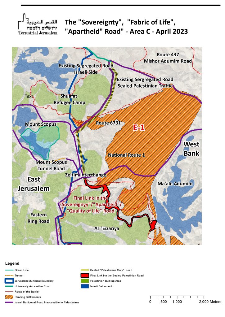
There are three major roads traverse the Ma’aleh Adumim Salient –
- The first road is National Route No. 1, which is a major expressway that begins in Tel Aviv and ends at the northern tip of the Dead Sea.
- The second road is Route 673, which traverses the salient in the north, leading from the West Bank north of Jerusalem and converging with Route No. 1 to the east of Ma’aleh Adumim. To date, both of these roads are accessible to both Israelis and Palestinians and therefore make Area C in the salient accessible to both. Indeed, it is not possible for a Palestinians living in the West Bank to the north of Jerusalem to travel to either Bethlehem, Al ‘Eizariya or Jericho, without using Routes No. 1 or 473, or both. In the context of this discussion, the word “Israeli” includes both the Palestinian citizens of Israel and Palestinian residents of East Jerusalem with Israeli ID cards. “Palestinian” refers to the Palestinians of the West Bank and Gaza.
- The third road, 4731, is unique in a number of ways. It runs north-south, with Hizma on the north and Az Za’ayem on the south. It is 4.9 kilometers in length and is a partitioned by a 5-meter-high wall. The eastern and southern side of the road is accessible to Israelis only and can be accessed on the north only by passing through a checkpoint. The western and northern side of the road are for Palestinians only. The road is sealed and can be accessed only at Hizmeh, ending in the village of Az Za’ayyem. The existence off two adjacent roads separated by a wall, designated for use based on nationality, has earned this segment the name of “the Apartheid Road.” The terminology used is significant. Saying the quiet part out loud, Bennett uses the term “Sovereignty Road,” mostly to assure the right that this isn’t being done to benefit the Palestinians. “Fabric of Life Road” is used vis-a-vis the international community in order to assert the opposite: this is really about serving the Palestinians. Given the visuals, it is clear who uses the term “Apartheid Road” and why.
The decision to build Route 4731 was made by Ariel Sharon in 2005. President Bush opposed Sharon’s efforts to build E-1, asserting that it would destroy the contiguity of any future Palestinian State. Stymied, Sharon responded by building Route 4731, the purpose of which was to create contiguity between the northern West Bank and the southern West Bank by means of a sealed Palestinian road that traverses the area between East Jerusalem and Ma’aleh Adumim. With this “transportational contiguity”, Sharon attempted to create a credible claim that E-1 does not impede the contiguity of a Palestinian State.
Construction work on Route 4731 commenced in 2005 and was partially completed in 2007. However, the United States and the wider international community remained unconvinced by the validity of Sharon’s “transformational contiguity.” The road was left incomplete in order. In order to allow traffic to proceed from the northern West Bank to the south, a 4.9-kilometer segment between Az Za’ayyam and Al ‘Eizariya, was never built rendering the road useless. The road remained closed and was only opened in 2019.
Since its opening in 2019, settlers have used the road to travel from the northern West Bank to Route No. 1, bypassing Jerusalem’s congested traffic. Palestinians use their side of the road to travel from Hizmeh to Az Za’ayyem. However, both Routes No. 1 in the West Bank, and Route No. 437 remain binational roads serving both Israelis and Palestinians and allow the Ma’aleh Adumim salient accessible to Palestinians.

In recent days, several indications have emerged that construction of the final portion of route 4371 is underway. The Civil Administration has notified the landowners, whose land will be seized, test borings (a preliminary stage conducted in the run up to the construction of a road) with be carried out in the coming days and weeks. Moreover, on April 18, the Government allocated 156 million shekels for the construction of the Zeitim Interchange, and another 80 million shekels for the Eastern Ring Road. The Zeitim Junction is the convergence point of Route No 1, Route No.637 and the Eastern Ring Road.
The completion of this short segment of Route 4731 will have the following impact:
- In the same geographical area, Area C to the East of Jerusalem (the Ma’ale Adumim Salient), there will be two distinct road grids. We have moved from two states to two peoples, to two road systems for two peoples.
- The “Israeli” road grid will be for Israelis only, with access denied to West Bank Palestinians. It will be fully integrated into the Israeli National Road system, erasing the Green Line.
- In this very same geographical location, there will be a Palestinian road grid, for Palestinians only. It will exclusively serve Palestinians, allowing them, at least theoretically, to travel from the northern West Bank to the southern West Bank on a sealed road, similar to the autobahn to Berlin prior to the collapse of the East German regime.
- A large part of Area C, which is located in the Ma’aleh Adumim Salient, will become inaccessible to Palestinians, while maintaining unimpeded access for Israelis. This will effectively neutralize Palestinian presence in the salient, as villages like Az Zayyem will be encircled by a security barrier, with entrance and exit only through a sealed Palestinian road. Bedouin communities, like those in Khan al Ahmar, who cannot be surrounded by a physical barrier, will be expelled, leaving only Israelis on the road.
- The completion of this 4.9 kilometer road stretch will bolster arguments that Israel has de facto annexed Area C. The Area C Ma’aleh Adumim Salient will be, to all intents and purposes, devoid of Palestinians. With a road system divided in ways starkly based on nationality, and with occupied territory becoming accessible to the occupier but not the occupied, it will also make attempts to deflect accusations of Israeli Apartheid far more difficult, while making those asserting that Israeli rule over the West Bank is a form of Israeli Apartheid more persuasive.