What is this about, and why is it important?
Want to know why? Start here.
On April 10, 2022, the Jerusalem Local Planning and Construction Committee will discuss the approval of a Town Plan submitted by the Israel Nature and Parks Authority (Plan No. 101-0674788). The objective of the Plan is to enlarge the boundaries of the existing National Park adjacent to the ramparts of the Old City, so that it will include most of the Mount of Olives, and parts of the Kidron Valley and Ben Hinnom Valley.
The ramifications of this plan are not routine. While the ringing of the Old City on the north and the south is proceeding apace by means of settlement expansion in Sheikh Jarrah and Silwan, respectively, the expansion of the National Park will remove the remaining obstacles for the development of settlement-related activities to the East. By doing so, it will complete the total encirclement of the Old City by means of settlements and settlement-related projects that are fragmenting the Christian and Palestinian expanses in the visual basin surrounding it.
This will further undermine the delicate equilibrium in the Old City of Jerusalem and its immediate environs, creating yet another crisis with the Christian world, and further destabilizing an already tense East Jerusalem.
We will examine below the plan, its background and impact.
- Background
- The Plan
- The Impact on Christian Equities
- Geopolitical implications
- The National Park Plan’s Critical Role in the Encirclement of the Old City
- The Expansion of the National Park: An Enterprise Serving and Implemented by the Settlers
- Conclusions
1. The Background
The Old City of Jerusalem and its surrounding visual basin are among the most important and sensitive sites in the world. In an area of approximately 4 square kilometers, the tectonic plates of Judaism, Christianity, and Islam meet, in a small area replete with hundreds of sacred sites that embody their respective faiths. This area is also the geographical core of the conflict between Israel and the Palestinians, and whatever happens here resonates far beyond the borders of Jerusalem.
In the first decades following the 1967 war, the State of Israel treated the Old City and its environs with reverence and restraint. Despite its aspiration to highlight the centrality of Jerusalem to the Jewish people throughout the millennia, the State of Israel also regarded its rule over Jerusalem holy sites as an historic trust of universal import, which is precious to billions of people of faith around the world. To this end, Israel adopted policies which sought to preserve and protect the special character of the ancient Jerusalem. In practical terms, the two major Town Plans approved during the 1970s sought to translate these principles into law. The 1977 AM/9 Town Plan aimed primarily at preservation: limiting construction and development in and around the Old City in a manner that would secure the city’s unique character. The 1970 AM/6 Town Plan created a National Park in the areas immediately surrounding the ramparts of the Old City. Both of these Plans remain in effect to this very day.
It is no coincidence that the National Park created by the AM/6 Plan did not apply to the Mount of Olives. The most important events in the life and death of Jesus occurred on the Mount of Olives. The Christian holy places on the Mount of Olives are physically and thematically linked to those within the walls of the Old City, and together they create tangible manifestations of the core of the Christian faith. The Planners and decision-makers believed, correctly, that the inclusion of these sites in an Israeli National Park would be perceived in the Christian world as an affront to their unique sacred character, to the holistic integrity of the Christian space between the Mount of Olives and the Old City, and as a manipulation of Christian narrative in the service of the extraneous national goals of the State of Israel.
2. The Plan

All of this is about to change. As noted, on April, 2022, the Jerusalem Local Planning and Construction Committee is to convene and discuss Town Plan 101-0674788. This Plan was submitted by Israel’s Nature and Parks Authority and expands the boundaries of the existing National Park by approximately 275 dunams (68 acres).
This is no mere technical amendment, but rather a major and substantive change that constitutes a radical departure from long-standing policy. The Plan expands the borders of the National Park in two areas:
- on the east of the existing Park, expanding it to the Mount of Olives and many of its holy sites, and to segments of the Kidron Valley nearby;
- on the southern flank of the existing Park, including the southern slopes of the Ben Hinnom Ravine.
There are numerous landowners within the borders of the Plan, the most prominent of which are the Latin churches (generally by means of the Custodia Terra Sancta), and the Greek Orthodox and Armenian Churches, as well as numerous private Palestinian landowners. The new borders of the Plan create buffers between the Palestinian neighborhoods in the Old City basin – Silwan, Ras al-Amud, A-Tor, A Sawanah and Wadi Joz.
3. The Impact on Christian Equities
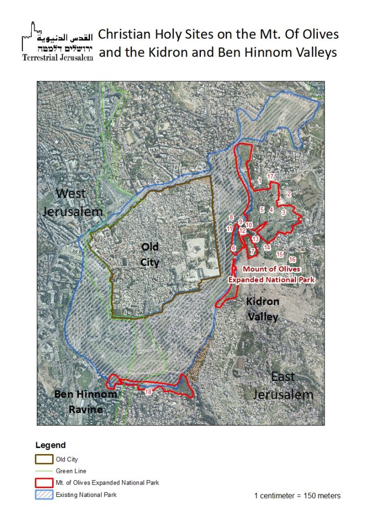
Below is a map of the Christian holy sites on the Mount of Olives. Many of the sites are located within the formal boundaries of the Park, some are surrounded by it, and others immediately adjacent to the boundary of the Park. Two additional sites, the Greek Orthodox Hakel Dama Monastery and the Karaite cemetery are located inside the Park, on the slopes of the Ben Hinnom Ravine.
Incorporating some of the most sacred important sites of Christianity into an Israeli National Park will affect the relationship between Israel and the Christian world. It will be interpreted as a display insensitivity, indifference and a cavalier disregard towards Jerusalem’s Christian churches and believers around the world as it will affect the integrity of Christian holy sites:
- The boundaries of the Plan fragment the holistic Christian presence on the Mount of Olives. By creating a narrow “Christian corridor” containing important holy sites that are technically outside the borders (but functionally within them), the Park splits the sacred space on the Mount in two, creating two smaller, disconnected spaces to the north and south of the corridor. This mapping reflects a view that the holy sites are isolated slivers of Church property, disconnected from one another and firmly embedded into a public domain that is unabashedly an Israeli National Park. This fragmentation will likely be viewed as a violation of the Mount’s unique character, which leads to a significant dilution of the palpable Christian presence on the Mount, has a detrimental impact on the manner that Christian faith is articulated by these sites, and disrupts the coherent inter-relationships among them.
- Under current circumstances (January 2022), the Plan is submitted against the backdrop of tense relations between Jerusalem’s churches and the Israeli government, as reflected in the letter released on December 13, 2021 by the Heads of Patriarchates and Churches in Jerusalem and the December 22 response of the Israeli Ministry of Foreign Affairs (see our recent report). Advancing such a Plan at this time creates a real possibility that the existing tensions will turn into an unprecedented crisis between Israel and the Christian world, especially with the Catholic Church and the Greek Orthodox Church, which are the largest and most influential among them.
- As seen below, the Plan will no doubt be interpreted as part of a systematic Israeli policy that seeks to engrave the increasingly hegemonic Jewish-Biblical narrative of East Jerusalem settlers on the landscape surrounding the Old City. This will marginalize both the Christian and Islam equities in that landscape.
- The Plan will strengthen the end-of-days evangelical churches that support a “very specific” Israel (one in which Netanyahu alone can be Prime Minister, and with little sympathy for the current Israeli government) who will bless the Plan as an integral component of the saga of the approaching end of days and Rapture. For the highly politicized, messianic evangelical movements, Israeli hegemony over all of Jerusalem, including Christian and Muslim holy sites, is part of the divine scheme in anticipation of the end-of-days. The Plan will empower those elements within the Christian world who are hostile to the current government, while weakening the historic churches that generally view Israel sympathetically.
4. The Geopolitical Implications
The provisions of the 1977 AM/9 Plan have proven to be effective in protecting the character of the Mount of Olives and no additional regulation is needed. The Churches themselves are vigilant and fastidious in protecting the unique qualities of the Mount. Absent any justification for the Plan in terms of a genuine concern for the protection and preservation of natural assets and historical sites, it is starkly evident that it is driven exclusively by unspoken, yet clearly identifiable ulterior motives.
For many years, the Israel Nature and Parks Authority (“the INPA”) together with other similar associated governmental bodies, such as the Israel Antiquities Authority, served as the long arm and subcontractors of the East Jerusalem settler organizations. The objective of these symbiotic relationships are clear and coherent:
- encompassing of the Old City through settler-controlled built-up areas, national and municipal parks and trails towards the end of securing the territorial integration of the Old City and its visual basin into the borders of pre-1967 Israel;
- creating a public domain in which the landscape is embedded with distinct expressions of the pseudo-Biblical ideology of the East Jerusalem settlers, while marginalizing the Christian and Muslim presence and ties to Jerusalem;
- fragmentating the urban fabric of Palestinian East Jerusalem in a manner that further undermines the very possibility of a future permanent status agreement.
These policies are not new and have driven the actions of Israel in and around Jerusalem’s Old City for many years. What IS new is the aggressive application of these policies to Jerusalem’s holy sites, in the framework of a strategic thrust to galvanize sole Israeli control and rule over all of Jerusalem, East and West.
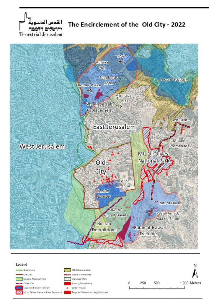
The Plan is not an isolated event. One of the major manifestations of these policies may be found in numerous Israeli projects currently being implemented in and around the settlement enclaves to the north of the Old City, in Sheikh Jarrah, and to its south in Silwan. This entails a number of major government and settler projects that aspire to create a pincer maneuver that will surround the Old City with settlements and a settler-inspired public domain, effectively cutting off the Old City and its visual basin from the rest of East Jerusalem. We will review them below:
Sheikh Jarrah. The encirclement of the Old City to the north is being achieved by creating a continuous territorial area that creates a link between Sheikh Jarrah and the ultra-Orthodox neighborhoods of pre-1967 Israeli Jerusalem to the west, and an additional territorial link between Sheikh Jarrah and Mount Scopus to the east and the north. The following schemes, among others, aim to serve that objective:
- For the first time since June 1967, we are on the cusp of large-scale evictions of entire Palestinian communities, in the area of Shimon Hatzadik )Simon The Righteous) and Um Haroun quarters of Sheikh Jarrah, jointly by the Government of Israel and the East Jerusalem settler.
- The chain of settlements compounds encircling the Old City on the north is comprised of the National Insurance Institute, Shimon Hatzadik and Um Haroun neighborhoods, the headquarters of the Border Police, the headquarters of the Amana settler movement, Shepherds’ Hotel, National Police headquarters, etc. This, for the first time, is transforming a settlement enclave – Sheikh Jarrah – into a territorial extension of pre-1967 Israel.
- A Plan that has been devised and is being promoted by the General Guardian entails razing of Palestinian Um Haroun neighborhood with its 30 homes, and replacing it with a new Israeli settlement neighborhood on its ruins.
- A series of public parks are being created, devised to linking the settlements within Sheikh Jarrah, and connecting them to the broader encirclement of the Old City. Such Parks are being created on the ruins of the recently razed bus complex, together with a new Municipal park on the slopes of Shimon Ha-Tzadik, the Planned Kidron Portal Park linking to the Old City Basin National Park, etc.
- The yeshiva for “born again” Jews, “Ohr Sameach”, in the heart of Sheikh Jarrah, while demolishing a Palestinian home to build a school for Palestinians, facilitates the linkage of settlement projects.
- There are large-scale investments in infrastructure (roads, sidewalks, drainage, parking etc.) in those areas serving the settlers, while Palestinian areas remain neglected.
Silwan: The southern encirclement of the Old City entails creating physical built-up link between the Old City and the settlement enclaves to the south, supplemented by National Parks which connect the Old City and the Mount of Olives.
- This entails the creation and/or expansion of a succession of settlements to the south and east of the Old City: Wadi Hilweh/City of David, Batan al-Hawa/Yemenite Quarter, Ras al-Amud/Ma’ale Zeitim, and the Mount of Olives.
- As in Sheikh Jarrah, there is a looming possibility that the government-supported settlers will displace hundreds of Palestinian residents from their homes in Batan al-Hawa.
- While there has already been a surge in the number of house demolitions in two targeted areas that are coveted by the settlers in Silwan, there are hundreds of additional pending demolition orders that will allow for large-scale displacement of hundreds of Palestinian residents in a scope not witnessed since 1967. In the al-Bustan quarter, there are 72 outstanding demolition orders (which have been stayed by the Court until February 12, 2022) and another 52 outstanding demolition orders in Wadi Yasul, both in Silwan.
- The Israeli government is actively promoting a Plan to build a cable car that will connect West Jerusalem to the settlement in Silwan and Dung Gate.
- In January 2022, the Moriah Corporation, owned and controlled by the Government of Israel and the Jerusalem Municipality, sponsored a plan submitted by the Elad settler organization to build a foot-bridge over the Ben Hinnom Ravine, above privately owned Palestinian properties.
It is noteworthy that these Plans are not merely on the drawing boards, and in recent years have been systematically and methodically implemented, step by step, with growing frequency.
5. The National Park Plan’s Critical Role in the Encirclement of the Old City
Whereas these settlement-related activities aim to achieve the total encirclement of the Old City, there has been, to date, two major obstacles that have prevented the completion of that encirclement to the east: Church properties and their holy sites, and the existence of the Palestinian neighborhoods of a-Tur and a-Sawana, all located on the Mount of Olives.
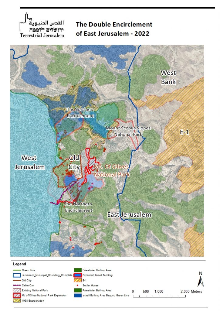
This map leaves no room for doubt: the purpose of expanding the National Park is to complete the encirclement of the Old City by means of fragmenting the Christian and Palestinian spaces, and neutralizing the impact of each.
These are not routine developments, and they have far-reaching implications on any potential future agreement between Israel and the Palestinians. As this map illuminates, the inner encirclement of Jerusalem’s Old City is being complemented by steps to ring greater Jerusalem with settlements. In fact, the Mount Scopus Slopes National Park physically links the National Parks surrounding the Old City with the notorious E-1 Plan to the east, in the West Bank. These Plans are no mere concepts, and the Plans of encirclement of the Old City, as well as large-scale game-changing settlement Plans, such as E-1, Atarot, the Lower Aqueduct are being expedited in ways that the Netanyahu governments did not dare.
6. The National Park: An Enterprise Serving and Implemented By The Settlers
The term “National Park” evokes benign, innocent associations. Who could possibly oppose the INPA in fulfilling its sacred mission of preserving the natural landscape and historical sites to which it is entrusted under law?
Describing the INPA’s role in such a manner could not be further from the truth, and portraying the National Park as an innocent endeavor of preservation requires willfully ignoring the stark realities: the relationship between the INPA and the settlers of East Jerusalem is so intimate and symbiotic that they are virtually indistinguishable.
It has long been widely acknowledged that the most important sites surrounding the Old City of Jerusalem, which have been entrusted under law to the INPA, have been turned over exclusively to the Elad settler organization. The ideological DNA of the settlers has been spliced into the organizational policies of the INPA, which in turn has outsourced many of its authorities to the Elad settlers, to whom they have divested many of their most important assets. Control of these properties are vested exclusively in the settlers, and none others.
These observations are not ours alone, and are totally corroborated by an investigation conducted in 2016 by Israel’s State Comptroller into the actions of the INPA and the Israel Antiquities Authority (“IAA”) in the sites surrounding the Old City:
“The Old City basin in Jerusalem has sites of national, religious, historical, spiritual, archaeological and cultural importance…the dereliction of [the INPA and IAA] led to a situation in which, in practice, the [Elad settler] association became a major factor in the area of management and operation of tourist sites in the Old City basin in Jerusalem, without substantial oversight by the state authorities in charge of the area and its sites…the transfer of [rights and authority] to a private body without due oversight and in contravention of proper administrative standards is tantamount to a total disavowal by the State of its authorities”.
The de facto control of the major sites under INPA’s formal authority can be found throughout the existing National Parks:
- The City of David National Park is also the contemporary Palestinian neighborhood of Wadi Hilweh/Silwan. Its 5000 Palestinian residents sit atop one of the world’s most important archeological sites of Biblical Jerusalem. Since 1991, with massive assistance from the government of Israel, the Elad settler organization has been displacing Palestinian families and taking over their homes.
However, Elad’s powerful stranglehold over Silwan is multiplied by its control of the public domain: INPA has transferred management and control of the National Park to Elad and their partnership is visible at all levels: the Elad and INPA logos appear jointly at the entrance to the park; the staff wear t-shirts with both logos; the entrance fee is paid to Elad; largescale tunneling and excavations are taking place under the privately owned Palestinian homes by the settlers, with the blessing of INPA. The settler headquarters, to be built atop a major archeological site in the Park, will be the terminal of the Old City cable car. Elad does not conceal the fact that while managing these sites, it seeks to serve only the settlers’ agenda and narrative. Hence, while other Israel’s National Parks are open on Shabbat and Jewish Holidays; not so with the City of David National Park, even if the majority of residents who live within its boundaries are Palestinians. Similarly, Hezekiah’s Tunnel, an ancient tunnel hewn in bedrock and a highly important historical artifact, serves as a mikveh (ritual bath,) exclusively for the settlers.
- The Ben Hinnom Ravine lies to the south and west of the City of David Park. The newly expanded National Park under discussion will include additional areas at this location, including Church Institutions and the Karaite cemetery and private Palestinian lands. The land of Palestinian residents of Abu Tor has already come under control of the Elad settler organization, based on a joint venture agreement signed with the INPA in 2020. As in the City of David, this agreement enabled Elad to establish an “ancient biblical farm”. It has started engaging in terracing, planting, creating trails – much on the Palestinian privately owned land, upon whose properties the site is located. In order to overcome the issues of private ownership, INPA and Elad facilitated the issuance of “Municipal Gardening Orders” which allow them to create their Biblical park on private Palestinian property.
The shared agenda of Elad and the INPA are on full display in the Ben Hinnom Ravine: containing the Palestinian residents of Abu Tor and denying them any possibility to develop, while engraving on the landscape pseudo-Biblical themes often reminiscent of a theme park, a “Disneyfication” of Jerusalem and its sacred and historical sites.
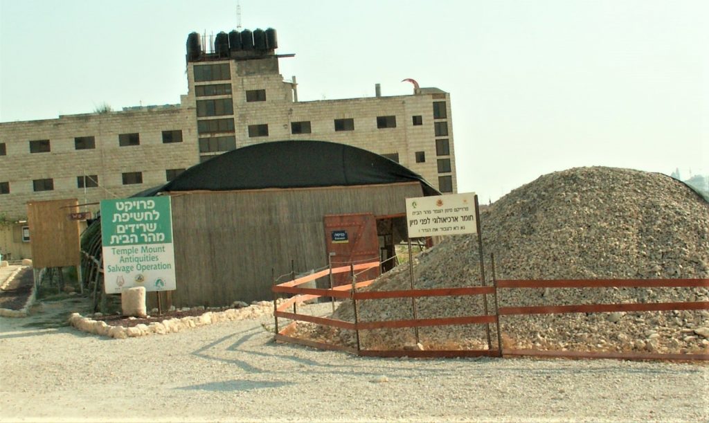
- The Tzurim Valley National Park. To the north of the City of David National Park, lies what is now dubbed “the Tzurim Valley” National Park, which descends from Mount Scopus/the Mount of Olives to the Kidron Valley/Wadi Na’ar below the Old City. Here, too, the Elad settlers and the INPA are working hand in glove. At base of the valley, Elad operates a site where, in the past, they sifted through debris from the Temple Mount, as a joint endeavor of Elad and INPA (see picture). In recent years, the site has become a recreational center called “the Archeological Experience“, where participants are invited to “…become archaeologists for a day and hold ancient history in [their] hands”. In addition, the Elad settlers advertise hikes and orienteering games in the National Park. In the past, the residents of A Tur would harvest the olives in the Tzurim Valley. Now that it is a National Park, they are driven off by park wardens.
The symbiosis between the settlers and the INPA is neither new, nor are its objectives in any doubt. In 2002, the late settler leader, MK Benny Elon stated that the eviction of Palestinian residents in Shimon Ha-Tzadik area of Sheikh Jarrah is “…part of a Plan to build … outposts around the Old City, towards the goal of surrounding it and preventing the division of Jerusalem…” in a manner which will “…be a continuum of two kinds: ‘green lungs’, open areas and National Parks owned by the State and its organs, alongside of small Jewish neighborhoods, all of which will be incorporated into existing sites in Jewish possession“.
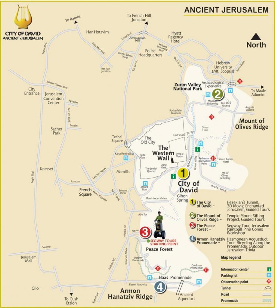
Consequently, it comes as no surprise that the Elad setters’ map of Ancient Jerusalem – their sphere of influence, as they themselves perceive it – includes the areas to be included in the expanded National Park, literally and figuratively viewed by them as part of their “home turf”.
7. The Conclusions
The Plan to expand the Old City Basin National Park purports to address problems that simply do not exist: the existing legal arrangements are more than adequate in protecting the unique character of the Mount of Olives. The motivations underlying the scheme have nothing to do with preservation, and the motives are entirely ulterior motives: the ideology of the Biblically motivated settler organizations and the Government that willingly does their bidding.
The Plan will:
- Constitute a gratuitous violation of the historic, cultural and religious integrity of the Mount of Olives.
- Seal the adjacent Palestinian neighborhoods to their existing contours, further fragment the urban fabric of East Jerusalem, and severely proscribe what Palestinian landowners may do on their properties inside the Park.
- Place some of the most important sacred sites in Christianity inside the Park, surrounded by or contiguous with an Israeli National Park, which to all intents and purposes is managed by the most controversial settler organization in Israel.
- Contribute to the further marginalization of the Christian, Muslim and Palestinian equities in Jerusalem, while articulating the primacy of the Biblical Jewish narrative and relegating the other stakeholders to the role of tolerated minority, at best.
- Contribute to the encirclement of the Old City and its environs and its integration into pre-1967 Israel, while sealing it from the rest of Palestinian East Jerusalem.
- The Plan is so insensitive and aggressive in nature that it would have been unthinkable even a few short years ago. Today, it threatens to undermine the stability of Jerusalem, violate its cultural and religious equilibrium and create facts on the ground that will make future political agreements inordinately more difficult.