Plans for IDF Colleges on Mt. of Olives Deposited for Public Review & Explanation of Location
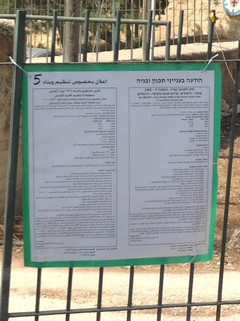
On the heels of the approval of the Mordot Gilo settlement plan for 797 units on October 18, on October 19 we discovered that the plan for the construction of the IDF War Colleges on the Mount of Olives (Town Plan 51870) has been formally published for public review – a fact we discovered after the public announcement was put on the gate of the Augusta Victoria Hospital on the Mount of Olives (photo). This means that the 60-day period in which objections may be filed has commenced.
As noted in previous TJ reporting, the pace of approval of this plan has been quite rapid, and it is clear that it is being fast-tracked. The plans involves the construction of an 8-story structure, 5 stories of which will be built into the ridge, with 41,480 square meters of built up space. Back on July 2, 2012, the Regional Planning Committee took up Town Plan 51870 and adopted a decision to deposit the plan for public review; we have been awaiting/anticipating its deposit ever since. As a reminder: once the plan was referred to the Regional Planning Committee by the Jerusalem Municipal Planning Committee (back in April), the Regional Planning Committee had the option of rejecting the plan, demanding amendments, or approving it for public review. The Regional Planning Committee operates under the framework of the Interior Ministry and is composed largely of representatives of various government ministries, meaning that the Government of Israel’s position nearly always prevails within the committee. All of which points to the fact that this plan could not have moved forward unless the Netanyahu government wanted it to.
The deposit of Town Plan 51870 will likely receive wide attention since this is a formal and very public act. A press release (Hebrew) published previously by Israel’s Ministry of Interior noted that other sites in Jerusalem were examined, but this was found to be “optimal.” Notably, the Ministry of Interior did little to hide why the site was optimal. Stating that the site is adjacent to the settler inspired Tsurim National Park on the slopes of the Mount of Olives, the press release asserts that “…the construction of the IDF colleges in Jerusalem is a central pillar in strengthening Jerusalem as the center of national governmental institutions…”
Once the 60-day review period has elapsed, there will be a new hearing (if necessary) to consider objections (assuming there are any), and then the Committee will either approve the plan or demand amendments – a process that is generally completed within 30 days of the original 60-day review period, but can take longer in cases that are complicated or politically delicate (like the Mughrabi Gate case). The bottom line being, this plan is now in the far-advanced stages, but should the Netanyahu government come to its senses, it still has the ability to slow it or stop it.
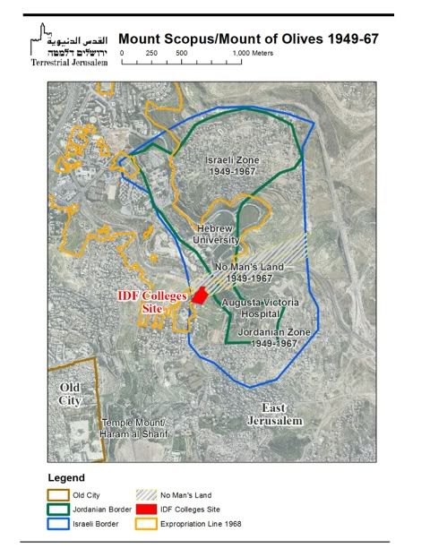
Finally, it is worth addressing the fact that some reporting has suggested that this plan deals with construction east of the Green Line. Such reporting is inaccurate, since the Green Line is not relevant in this particular case. The designation of the Mt. Scopus/Mt. of Olives zones pre-date the Green Line, and were agreed upon in the framework of “Agreement for the Demilitarisation of Mount Scopus area” of July 7, 1948 (before the 1949 armistice). There was never an agreed map. There was an Israeli map, dated July 7, 1948 and a Jordanian map dated July 21, 1948. The absence of an agreed map led to skirmishing between Israeli and Jordanian forces, often deriving from fact that “…the ‘7 July 1948 map’ recognized as valid by Israel covers a larger area than the ‘21 July 1948 map’ recognized as valid by Jordan, there are on Mount Scopus sectors which Israel considers as being within the Demilitarized Zone and Jordan in Jordanian-controlled territory” (Note by the Secretary General, June 7, 1958). Finally, in spite of the disputed boundaries, the Mount Scopus Agreement established “…a no-man’s-land location extending for approximately 200 yards along the main road between the Augusta Victoria and Hebrew University buildings, with suitable check-posts established at each end” (Article 2 of the Agreement).
This map of the Mount Scopus/Mount of Olives area as it was between 1949-1967 designates the Israeli boundaries of July 7, 1948, the Jordanian boundaries of July 21, 1948 and the established no-man’s zone between the two sectors. The map is based on the original Israeli map of 1948, the original Jordanian map of 1948, a map presented in 1975 by Uzi Narkis, Israeli Commander of the Central Command during the 1967 war, and an unclassified CIA map from 2005.
The land on which the site is located, (Parcels 1 and 2 in Bloc 21) belonged to two Palestinian families, the El Khatibs and the El Imams, respectively. No-man’s land, as designated on our map, was entirely inaccessible to both sides, whether civilian or military, and only UN forces entered the area sporadically. These became Israeli state property in January 1968, when they were expropriated by Israel from their Palestinian owners. We have superimposed on this map the precise location of the IDF Colleges as appearing in the GIS data of the official statutory document, and the borders of the expropriation of the site.
From the foregoing it is clear that under no circumstances can it be claimed that the site of the planned IDF Colleges was located in the Israeli sector of the Mount Scopus enclave. According to the relevant Jordanian map, the site is located within Jordanian territory; under the Israeli map, the site is located in no-man’s land. Either way, the site itself was not accessible to Israelis, Jordanian or Palestinians. Moreover, the site in question was privately-owned Palestinian land that were expropriated by the Government of Israel in 1968 – and indeed the border of the plot is identical to the extreme western boundary of the expropriation line.
We have examined this issue in depth in the hopes of putting to rest the spurious claims that the status of the site is somehow “unclear” (it isn’t) and that there is a compelling Israeli claim that this area “was always under Israeli control” (it wasn’t).